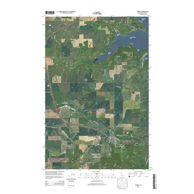
2014 Map of Worley
USGS Topo · Published 2014About this map
The city of Worley serves as the inland hub for this Kootenai County landscape, where the plateau agriculture of northern Idaho meets the deeply indented western shore of Coeur d'Alene Lake. To the north and east, the shoreline is defined by several distinct inlets, including Windy Bay, 16 to 1 Bay, and Cave Bay, which wrap around local landmarks like Mil'o'lmkhw Point and Rockford Point. The transition from the water's edge to the high ground is marked by significant elevations, notably Worley Mtn and McCartney Butte, which overlook the winding course of the N Fork Rock Cr. For those researching local heritage, the map identifies specific community sites such as Saint Michaels Cem, Worley Cem, and the settlement of Mozart. The presence of Camp Four Echoes and the Alexander McDowell Rest Area reflects the area's modern role as a destination for recreation and travel along the routes connecting the lake to the interior uplands.
Find a feature on this map
63 named features on this map. Tap any name to fly to it.
Don’t see what you’re looking for? This feature index may not catch every label — zoom into the map to look around manually.
Map Details
Editions of this 2014 Worley Map
This is the sole edition of this map. No revisions or reprints were ever made.
Other maps of this area

1901 · Spokane
USGS Topo · 1:125,000

1903 · Oakesdale
USGS Topo · 1:125,000

1903 · Rathdrum
USGS Topo · 1:125,000

1905 · Oakesdale
USGS Topo · 1:125,000

1949 · Greenacres
USGS Topo · 1:62,500

1951 · Greenacres
USGS Topo · 1:62,500

1954 · Fairfield
USGS Topo · 1:62,500

1955 · Spokane
USGS Topo · 1:250,000

1957 · Plummer
USGS Topo · 1:62,500

1957 · Coeur D'Alene
USGS Topo · 1:62,500