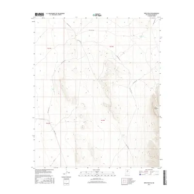
2017 Map of Wrye Peak SW
USGS Topo · Published 2017About this map
The Oscura Mountains anchor the eastern edge of this landscape in Socorro County, New Mexico, where the high desert terrain transitions into the restricted corridors of the White Sands Missile Range. The map details a network of specialized transit routes, including WSMR S Route 3501 and WSMR S Route 3610, which underscore the region's mid-century and modern military utility. Strategic water catchments like Bulldog Tank, Cornet Tank, and Smith Tank are the only named hydrological features in this arid environment, revealing the vital infrastructure required to support activity in such a remote area. These "tanks" often represent critical points of interest for historical research into early ranching or military operations before the landscape was fully cordoned for government use.
Find a feature on this map
16 named features on this map. Tap any name to fly to it.
Don’t see what you’re looking for? This feature index may not catch every label — zoom into the map to look around manually.
Map Details
Editions of this 2017 Wrye Peak SW Map
This is the sole edition of this map. No revisions or reprints were ever made.
Other maps of this area

1918 · Oscura Peak
USGS Topo · 1:125,000

1948 · Carthage
USGS Topo · 1:62,500

1948 · Granjean Well
USGS Topo · 1:62,500

1948 · Bingham
USGS Topo · 1:62,500

1948 · Mockingbird Gap
USGS Topo · 1:62,500

1954 · Tularosa
USGS Topo · 1:250,000

1958 · Tularosa
USGS Topo · 1:250,000
1981 · Greens Baber Well
USGS Topo · 1:24,000
1981 · Trinity Site
USGS Topo · 1:24,000
1981 · Wrye Peak NW
USGS Topo · 1:24,000