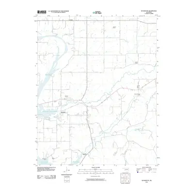
2010 Map of Wyandotte
USGS Topo · Published 2010About this map
Grand Lake O' The Cherokees dominates the western portion of this 2010 landscape, where the waters reach into Sycamore Cove. The settlement of Wyandotte serves as a central hub, while the smaller community of Kellyville sits to the south along the winding road network. The terrain is marked by distinctive natural divisions, including Jackson Prairie in the north and the lower Mason Springs Valley to the east. For those tracing local heritage, the Wyandotte Cemetery and Brown Cemetery are clearly noted. The map reflects a rural economy shaped by expansive prairie lands like Yankee Bill Prairie and the sheltered environment of Modoc Valley. The road system, characterized by numbered routes such as S 640 Rd and Cayuga Rd, provides the framework for this corner of Oklahoma where water and open prairie define the settlement patterns.
Find a feature on this map
50 named features on this map. Tap any name to fly to it.
Don’t see what you’re looking for? This feature index may not catch every label — zoom into the map to look around manually.
Map Details
Editions of this 2010 Wyandotte Map
This is the sole edition of this map. No revisions or reprints were ever made.
Other maps of this area

1907 · Wyandotte
USGS Topo · 1:125,000

1909 · Wyandotte
USGS Topo · 1:125,000

1949 · Seneca
USGS Topo · 1:24,000

1949 · Racine
USGS Topo · 1:24,000

1950 · Seneca
USGS Topo · 1:24,000

1950 · Racine
USGS Topo · 1:24,000

1954 · Tulsa
USGS Topo · 1:250,000

1958 · Tulsa
USGS Topo · 1:250,000
1960 · Peoria
USGS Topo · 1:24,000

1961 · Miami SE
USGS Topo · 1:24,000