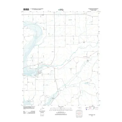
2012 Map of Wyandotte
USGS Topo · Published 2012About this map
Wyandotte serves as a central hub in this northeastern Oklahoma landscape, situated at the confluence of several key waterways and transportation routes. The BNSF Railway cuts through the territory, passing near the small settlement of Kellyville and across Lost Cr. This region is defined by its distinct prairie and valley formations, including Jackson Prairie to the north and Yankee Bill Prairie to the east. The expansive Grand Lake O' the Cherokees dominates the western edge of the map, its shoreline forming intricate inlets like Sycamore Cove. For those researching local heritage, the map identifies significant sites such as the Wyandotte Cem and Brown Cem, alongside natural landmarks like Mason Springs Valley and Modoc Valley. The grid of rural roads, including Cayuga Rd, illustrates the persistent settlement patterns throughout Ottawa County.
Find a feature on this map
85 named features on this map. Tap any name to fly to it.
Don’t see what you’re looking for? This feature index may not catch every label — zoom into the map to look around manually.
Map Details
Editions of this 2012 Wyandotte Map
This is the sole edition of this map. No revisions or reprints were ever made.
Other maps of this area

1907 · Wyandotte
USGS Topo · 1:125,000

1909 · Wyandotte
USGS Topo · 1:125,000

1949 · Seneca
USGS Topo · 1:24,000

1949 · Racine
USGS Topo · 1:24,000

1950 · Seneca
USGS Topo · 1:24,000

1950 · Racine
USGS Topo · 1:24,000

1954 · Tulsa
USGS Topo · 1:250,000

1958 · Tulsa
USGS Topo · 1:250,000
1960 · Peoria
USGS Topo · 1:24,000

1961 · Miami SE
USGS Topo · 1:24,000