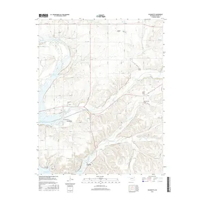
2016 Map of Wyandotte
USGS Topo · Published 2016About this map
The confluence of the Spring River and Lost Creek defines the landscape of northeastern Oklahoma, where the town of Wyandotte serves as a central hub. This 2016 survey shows the community's layout near the northern reaches of Grand Lake O' the Cherokees, including the local Wyandotte Cem and the southern settlement of Kellysville. The map illustrates a transition from the level terrain of Jackson Prairie and Yankee Bill Prairie into the more dissected topography of Modoc Valley and Mason Springs Valley. Genealogists will find significance in the documented locations of several family and community landmarks, including the Modoc Cem and Brown Cem. The area is characterized by a dense network of country roads such as Turtle Dr and E Broadway Ave that connect the small valley settlements and prairies across the quadrangle.
Find a feature on this map
50 named features on this map. Tap any name to fly to it.
Don’t see what you’re looking for? This feature index may not catch every label — zoom into the map to look around manually.
Map Details
Editions of this 2016 Wyandotte Map
This is the sole edition of this map. No revisions or reprints were ever made.
Other maps of this area

1907 · Wyandotte
USGS Topo · 1:125,000

1909 · Wyandotte
USGS Topo · 1:125,000

1949 · Seneca
USGS Topo · 1:24,000

1949 · Racine
USGS Topo · 1:24,000

1950 · Seneca
USGS Topo · 1:24,000

1950 · Racine
USGS Topo · 1:24,000

1954 · Tulsa
USGS Topo · 1:250,000

1958 · Tulsa
USGS Topo · 1:250,000
1960 · Peoria
USGS Topo · 1:24,000

1961 · Miami SE
USGS Topo · 1:24,000