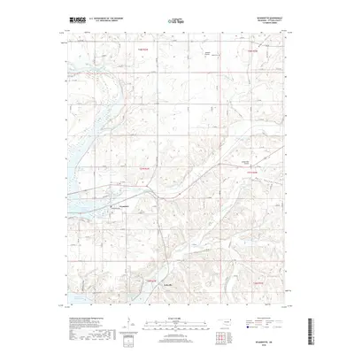
2018 Map of Wyandotte
USGS Topo · Published 2018About this map
Wyandotte serves as the focal point of this northeastern Oklahoma landscape, situated where the Spring River and Lost Creek contribute to the northern reaches of Grand Lake O' the Cherokees. The map reveals a transition from the structured street grid of the town to the expansive agricultural and natural terrain of the surrounding prairies. Notable landforms like Jackson Prairie, Yankee Bill Prairie, and Mason Springs Valley define the local topography, which is carved by a network of drainage systems including Sycamore Creek, Brush Creek, and Roark Cr. For those researching local family history, the map identifies specific points of interest such as Modoc Cem near Modoc Valley and Brown Cem near Sycamore Cove. This 2018 survey illustrates the modern rural infrastructure, with a dense network of county roads like E 150 RD and E 100 RD connecting smaller communities like Kellyville to the regional hub at Wyandotte.
Find a feature on this map
79 named features on this map. Tap any name to fly to it.
Don’t see what you’re looking for? This feature index may not catch every label — zoom into the map to look around manually.
Map Details
Editions of this 2018 Wyandotte Map
This is the sole edition of this map. No revisions or reprints were ever made.
Other maps of this area

1907 · Wyandotte
USGS Topo · 1:125,000

1909 · Wyandotte
USGS Topo · 1:125,000

1949 · Seneca
USGS Topo · 1:24,000

1949 · Racine
USGS Topo · 1:24,000

1950 · Seneca
USGS Topo · 1:24,000

1950 · Racine
USGS Topo · 1:24,000

1954 · Tulsa
USGS Topo · 1:250,000

1958 · Tulsa
USGS Topo · 1:250,000
1960 · Peoria
USGS Topo · 1:24,000

1961 · Miami SE
USGS Topo · 1:24,000