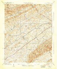
1938 Map of Wyndale
USGS Topo · Published 1938About this map
Walker Mountain anchors this 1930s landscape, casting long shadows over the parallel corridors of Rich Valley and Preston Valley. This era is defined by the heavy infrastructure of the Norfolk and Western Railway and the Lee Highway, which cut through the heart of the region near Wyndale and Wallace. The map reveals a dense network of rural community life, where small settlements like Greendale and Fractionville are tethered to the land by numerous small schools and churches. Notable local landmarks such as Bakers Chapel, Heavenly Rest Chapel, and the Rushtown School appear alongside family-named sites like the Whitaker Cem. The terrain is characterized by a series of high ridges and hollows, including King Ridge and Rust Hollow, which channeled the development of roads and homesteads along the banks of Beaver Creek and Wolf Creek.
Find a feature on this map
52 named features on this map. Tap any name to fly to it.
Don’t see what you’re looking for? This feature index may not catch every label — zoom into the map to look around manually.
Map Details
Editions of this 1938 Wyndale Map
3 editions found
Other maps of this area

1891 · Abingdon
USGS Topo · 1:125,000

1894 · Abingdon
USGS Topo · 1:125,000

1897 · Bristol
USGS Topo · 1:125,000

1902 · Bristol
USGS Topo · 1:125,000

1909 · Abingdon
USGS Topo · 1:96,000

1911 · Abingdon
USGS Topo · 1:125,000

1918 · Carterton
USGS Topo · 1:62,500

1934 · Wallace
USGS Topo · 1:24,000

1934 · Holston Valley
USGS Topo · 1:24,000

1934 · Brumley
USGS Topo · 1:24,000