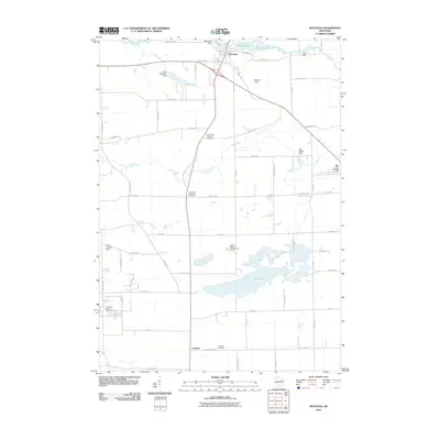
2010 Map of Wyocena
USGS Topo · Published 2010About this map
The village of Wyocena sits at the northern edge of this landscape, centered around the industrial and recreational nexus of Wyona Lake and the Wyocena Dam. The surrounding terrain in Columbia County is defined by its complex hydrology, with the Middle Branch Duck Creek and Rocky Run weaving through a patchwork of agricultural lands and natural preserves. Further south, the settlement of Lowville and the expansive Mud Lake characterize a more rural, open geography.
Find a feature on this map
57 named features on this map. Tap any name to fly to it.
Don’t see what you’re looking for? This feature index may not catch every label — zoom into the map to look around manually.
Map Details
Editions of this 2010 Wyocena Map
This is the sole edition of this map. No revisions or reprints were ever made.
Other maps of this area

1901 · Poynette
USGS Topo · 1:62,500

1902 · Portage
USGS Topo · 1:62,500

1955 · Randolph
USGS Topo · 1:62,500

1955 · Columbus
USGS Topo · 1:62,500

1957 · Madison
USGS Topo · 1:250,000

1960 · Madison
USGS Topo · 1:250,000

1962 · Poynette
USGS Topo · 1:62,500

1962 · Portage
USGS Topo · 1:62,500
1980 · North Bristol
USGS Topo · 1:24,000
1980 · Rio
USGS Topo · 1:24,000