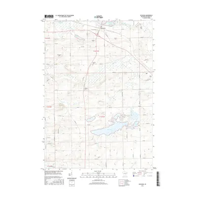
2016 Map of Wyocena
USGS Topo · Published 2016About this map
Wyocena sits at the northern edge of this agricultural landscape in Columbia County, defined by the winding course of Duck Creek and the Wyocena Millpond. The terrain is marked by a series of named fields, such as Knutson Field and Weatherbee Field, which suggest the enduring legacy of local farming families. To the south, the settlement of Loweville and the nearby Lowville Cem anchor the rural community, while the dual presence of the Rocky Run Catholic Cem and Rocky Run Protestant Cem further west illustrates the area's denominational history. Extensive wetlands surround the central Mud Lake, feeding into Rocky Run as it meanders toward the N Br Crawfish River in the southeastern corner. The map traces a network of county roads and historic routes like W Old Highway 16, connecting these small townships and scattered homesteads.
Find a feature on this map
68 named features on this map. Tap any name to fly to it.
Don’t see what you’re looking for? This feature index may not catch every label — zoom into the map to look around manually.
Map Details
Editions of this 2016 Wyocena Map
This is the sole edition of this map. No revisions or reprints were ever made.
Other maps of this area

1901 · Poynette
USGS Topo · 1:62,500

1902 · Portage
USGS Topo · 1:62,500

1955 · Randolph
USGS Topo · 1:62,500

1955 · Columbus
USGS Topo · 1:62,500

1957 · Madison
USGS Topo · 1:250,000

1960 · Madison
USGS Topo · 1:250,000

1962 · Poynette
USGS Topo · 1:62,500

1962 · Portage
USGS Topo · 1:62,500
1980 · North Bristol
USGS Topo · 1:24,000
1980 · Rio
USGS Topo · 1:24,000