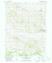
1980 Map of Wyoming West
USGS Topo · Published 1981About this map
The Wapsipinicon River winds through the southern reaches of this Jones County landscape, defining the rural character of eastern Iowa in the late twentieth century. Industrial and transit patterns are visible in the contrast between the active line of the Chicago Milwaukee St Paul and Pacific railroad passing through Hale and the abandoned Old Railroad Grade tracing through the north. The small town of Wyoming serves as a local hub, featuring a Golf Course and Chamberlain Park, while the surrounding agricultural townships of Madison, Wyoming, and Oxford are dotted with local landmarks like North Madison Cem and Madison Center Cem. Evidence of local extraction is noted at several Quarries and a Sandpit near the river, illustrating the region's reliance on local natural resources and a well-established network of small settlements including Center Junction and Onslow.
Find a feature on this map
29 named features on this map. Tap any name to fly to it.
Don’t see what you’re looking for? This feature index may not catch every label — zoom into the map to look around manually.
Map Details
Editions of this 1980 Wyoming West Map
This is the sole edition of this map. No revisions or reprints were ever made.
Other maps of this area

1889 · Tipton
USGS Topo · 1:62,500

1890 · Tipton
USGS Topo · 1:62,500

1891 · Monticello
USGS Topo · 1:62,500

1891 · Baldwin
USGS Topo · 1:62,500

1892 · Wheatland
USGS Topo · 1:62,500

1894 · Wheatland
USGS Topo · 1:62,500

1900 · Anamosa
USGS Topo · 1:125,000

1901 · Peosta
USGS Topo · 1:125,000

1901 · Rock Island
USGS Topo · 1:125,000

1901 · Stanwood
USGS Topo · 1:125,000