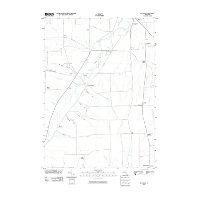
2010 Map of Wyoming
USGS Topo · Published 2010About this map
Oatka Creek carves a deep path through the Wyoming Valley, defining the landscape of central Wyoming County at the start of the 21st century. The topography is marked by a series of striking natural ravines or "gulfs," including Wyoming Gulf, Handyside Gulf, and Canaway Gulf, which drain into the main valley. The settlement at Wyoming sits at the heart of this network, surrounded by smaller hamlets like Pearl Creek, Covington, and Lagrange. For the local historian, the map identifies several distinct burial grounds such as the Covington Center Pioneer Cemetery and Saint Marys Cemetery. Industry and geology are noted through features like the Pioneer Salt Well near Saltvale, pointing to the region's historical salt mining, while the natural beauty of the area is represented by Cascade Falls along Cascade Brook.
Find a feature on this map
86 named features on this map. Tap any name to fly to it.
Don’t see what you’re looking for? This feature index may not catch every label — zoom into the map to look around manually.
Map Details
Editions of this 2010 Wyoming Map
This is the sole edition of this map. No revisions or reprints were ever made.
Other maps of this area

1904 · Batavia
USGS Topo · 1:62,500

1904 · Caledonia
USGS Topo · 1:62,500

1905 · Portage
USGS Topo · 1:62,500

1905 · Nunda
USGS Topo · 1:62,500

1943 · Mount Morris
USGS Topo · 1:24,000

1943 · Warsaw
USGS Topo · 1:24,000

1943 · Castile
USGS Topo · 1:24,000
1944 · Mount Morris
USGS Topo · 1:31,680

1944 · Stafford
USGS Topo · 1:31,680

1944 · Warsaw
USGS Topo · 1:31,680