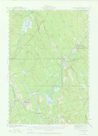
1941 Map of Wytopitlock
USGS Topo · Published 1966About this map
The Mattawamkeag River serves as the central artery for this remote portion of the Maine north woods, where the villages of Wytopitlock and Kingman grew around the junction of rail and water. Surveyed just before the mid-century, the map documents the intersection of the Maine Central and Canadian Pacific railroads, which facilitated the region's timber-driven economy. Small educational outposts like Knoxville Sch and Drew Sch are found near the riverbanks, alongside the Whitney Fire Tower on a high ridge. The landscape is a complex network of wetlands and streams, including the Wytopitlock Stream and Mattagodus Stream, with local family-named landmarks like Hawkins Ridge and Sweet Chopping Ridge providing geographical context for genealogists tracing ancestors in the North Yarmouth Academy Grant.
Find a feature on this map
66 named features on this map. Tap any name to fly to it.
Don’t see what you’re looking for? This feature index may not catch every label — zoom into the map to look around manually.
Map Details
Editions of this 1941 Wytopitlock Map
2 editions found

Other maps of this area

1920 · Winn
USGS Topo · 1:62,500

1931 · Springfield
USGS Topo · 1:48,000

1934 · Springfield
USGS Topo · 1:62,500

1940 · Danforth
USGS Topo · 1:62,500

1940 · Amity
USGS Topo · 1:62,500

1940 · Sherman
USGS Topo · 1:62,500

1940 · Mattawamkeag
USGS Topo · 1:62,500

1941 · Danforth
USGS Topo · 1:62,500

1941 · Amity
USGS Topo · 1:62,500

1941 · Scraggly Lake
USGS Topo · 1:62,500