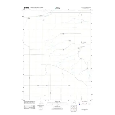
2012 Map of Y B O Canyon
USGS Topo · Published 2012About this map
Werner Ranch and several other family-named homesteads anchor this high-plains landscape in eastern Wyoming. The terrain is defined by a dense network of drainages and seasonal watercourses, including Box Elder Cr, Corn Cr, and YBO Cr, which have carved out numerous distinct canyons. Named features such as Busty Canyon, Sawmill Canyon, and Little Josh Canyon illustrate how the local geography was navigated and identified by ranchers. In the eastern portion of the map, Bogville Ranch and the Canyon View Ranch Airport highlight the logistical infrastructure required for this expansive ranching country. The southern half of the map transitions into a more regularized grid of rural roads, such as Co RD-216 and Road 30, providing access to the open range and scattered ranch properties.
Find a feature on this map
33 named features on this map. Tap any name to fly to it.
Don’t see what you’re looking for? This feature index may not catch every label — zoom into the map to look around manually.
Map Details
Editions of this 2012 Y B O Canyon Map
This is the sole edition of this map. No revisions or reprints were ever made.
Other maps of this area

1899 · Goshen Hole
USGS Topo · 1:125,000

1954 · Cheyenne
USGS Topo · 1:250,000

1958 · Cheyenne
USGS Topo · 1:250,000

1960 · Veteran
USGS Topo · 1:24,000

1960 · Diamond Flat
USGS Topo · 1:24,000

1960 · Needle Rock
USGS Topo · 1:24,000
1963 · Dickinson Hill
USGS Topo · 1:24,000

1963 · C S Ranch
USGS Topo · 1:24,000

1963 · Y B O Canyon
USGS Topo · 1:24,000

1963 · Klutz Canyon
USGS Topo · 1:24,000