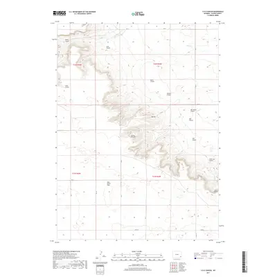
2017 Map of Y B O Canyon
USGS Topo · Published 2017About this map
The Goshen Hole Rim defines the dramatic topography of this Goshen County landscape, where the high plains of the Iowa Center Flats drop away into a complex network of drainages. The area is marked by numerous named coulees and canyons, including the prominent YBO Canyon and Sam Moore Canyon, which descend toward the northeast. This 2017 survey documents the modern rural infrastructure of the region, anchored by a section-line road network including RD 38 and Co RD 28 that services the scattered ranches and open range.
Find a feature on this map
31 named features on this map. Tap any name to fly to it.
Don’t see what you’re looking for? This feature index may not catch every label — zoom into the map to look around manually.
Map Details
Editions of this 2017 Y B O Canyon Map
This is the sole edition of this map. No revisions or reprints were ever made.
Other maps of this area

1899 · Goshen Hole
USGS Topo · 1:125,000

1954 · Cheyenne
USGS Topo · 1:250,000

1958 · Cheyenne
USGS Topo · 1:250,000

1960 · Veteran
USGS Topo · 1:24,000

1960 · Diamond Flat
USGS Topo · 1:24,000

1960 · Needle Rock
USGS Topo · 1:24,000
1963 · Dickinson Hill
USGS Topo · 1:24,000

1963 · C S Ranch
USGS Topo · 1:24,000

1963 · Y B O Canyon
USGS Topo · 1:24,000

1963 · Klutz Canyon
USGS Topo · 1:24,000