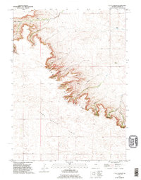
1990 Map of Y B O Canyon
USGS Topo · Published 1995About this map
Goshen Hole and the Iowa Center Flats define this pocket of Wyoming, where the dramatic break of the Y B O Rim separates high plateau from lower canyon systems. This 1990 revision shows a landscape of cattle ranching and seasonal water management, anchored by established spreads like Werner Ranch and Bogville Ranch. The topography is dominated by deeply incised drainages, including Y B O Canyon, Sawmill Canyon, and the curiously named Busty Canyon in the northwest. Water sources are critical in this arid terrain, with intermittent flows like Box Elder Creek and Josh Creek feeding into the canyons. Numerous wells and several springs are marked along the rim, highlighting the infrastructure necessary to support the isolated Smith Ranch and other operations in this sparsely populated region of Goshen County.
Find a feature on this map
25 named features on this map. Tap any name to fly to it.
Don’t see what you’re looking for? This feature index may not catch every label — zoom into the map to look around manually.
Map Details
Editions of this 1990 Y B O Canyon Map
This is the sole edition of this map. No revisions or reprints were ever made.
Other maps of this area

1899 · Goshen Hole
USGS Topo · 1:125,000

1954 · Cheyenne
USGS Topo · 1:250,000

1958 · Cheyenne
USGS Topo · 1:250,000

1960 · Veteran
USGS Topo · 1:24,000

1960 · Diamond Flat
USGS Topo · 1:24,000

1960 · Needle Rock
USGS Topo · 1:24,000
1963 · Dickinson Hill
USGS Topo · 1:24,000

1963 · C S Ranch
USGS Topo · 1:24,000

1963 · Y B O Canyon
USGS Topo · 1:24,000

1963 · Klutz Canyon
USGS Topo · 1:24,000