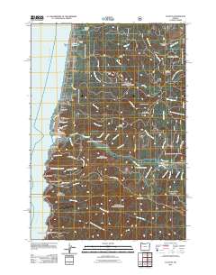
2011 Map of Yachats
USGS Topo · Published 2011About this map
Yachats sits at the intersection of the Pacific Ocean and the coastal mountain range, serving as a focal point for this 2011 survey of the Oregon coastline. The town's community infrastructure is well-defined, featuring the Yachats Post Office and Yachats Memorial Park, while smaller coastal settlements like San Marine, Reynoldsville, and Tillicum Beach dot the shoreline to the north. The presence of the Big Creek Log Pond near Camp Angell highlights the region's historical and ongoing relationship with the timber industry, contrasting with the preservation of the Cape Perpetua Area further south.
Find a feature on this map
67 named features on this map. Tap any name to fly to it.
Don’t see what you’re looking for? This feature index may not catch every label — zoom into the map to look around manually.
Map Details
Editions of this 2011 Yachats Map
This is the sole edition of this map. No revisions or reprints were ever made.
Other maps of this area

1918 · Mapleton
USGS Topo · 1:48,000

1920 · Heceta Head
USGS Topo · 1:62,500

1922 · Waldport
USGS Topo · 1:62,500

1940 · Mapleton
USGS Topo · 1:62,500

1942 · Waldport
USGS Topo · 1:62,500

1942 · Heceta Head
USGS Topo · 1:62,500

1942 · Tidewater
USGS Topo · 1:62,500

1945 · Mapleton
USGS Topo · 1:62,500

1953 · Salem
USGS Topo · 1:250,000

1954 · Salem
USGS Topo · 1:250,000