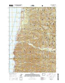
2014 Map of Yachats
USGS Topo · Published 2014About this map
The central Oregon coastline defines this region, where the town of Yachats sits at the mouth of the Yachats River. This 2014 survey documents the interface between the Pacific Ocean and the heavily forested slopes of the Siuslaw National Forest. Inland, the terrain rises sharply toward prominent summits such as Blodgett Peak, Yachats Mtn, and Kerby Mtn. The Oregon Coast Hwy provides the primary transit corridor, connecting coastal settlements like Tillicum Beach and San Marine.
Find a feature on this map
65 named features on this map. Tap any name to fly to it.
Don’t see what you’re looking for? This feature index may not catch every label — zoom into the map to look around manually.
Map Details
Editions of this 2014 Yachats Map
This is the sole edition of this map. No revisions or reprints were ever made.
Other maps of this area

1918 · Mapleton
USGS Topo · 1:48,000

1920 · Heceta Head
USGS Topo · 1:62,500

1922 · Waldport
USGS Topo · 1:62,500

1940 · Mapleton
USGS Topo · 1:62,500

1942 · Waldport
USGS Topo · 1:62,500

1942 · Heceta Head
USGS Topo · 1:62,500

1942 · Tidewater
USGS Topo · 1:62,500

1945 · Mapleton
USGS Topo · 1:62,500

1953 · Salem
USGS Topo · 1:250,000

1954 · Salem
USGS Topo · 1:250,000