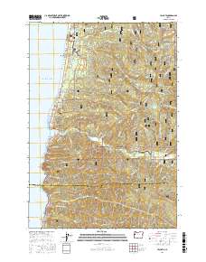
2017 Map of Yachats
USGS Topo · Published 2017About this map
The Yachats River meets the Pacific at the settlement of Yachats, a central point on this coastal survey where the Oregon shore transitions from residential pockets to the dense timber of the Siuslaw National Forest. The landscape is defined by the sharp rise of the coast range, with peaks like Blodgett Peak and Yachats Mtn standing watch over the shoreline. Natural coastal landmarks including Cape Perpetua, Devils Churn, and Cooks Chasm are clearly marked, illustrating the complex geology of the headlands. Inland, the map traces the intricate network of forest roads, such as Nat For Dev Rd 1045 and Eckman Creek Rd, which provide access to the ridges and saddles of the interior. Genealogists may find interest in the Carson Cem located along the river valley, while researchers can examine the boundaries of the Oregon Islands National Wildlife Refuge and the southern line between Lincoln and Lane counties.
Find a feature on this map
65 named features on this map. Tap any name to fly to it.
Don’t see what you’re looking for? This feature index may not catch every label — zoom into the map to look around manually.
Map Details
Editions of this 2017 Yachats Map
This is the sole edition of this map. No revisions or reprints were ever made.
Other maps of this area

1918 · Mapleton
USGS Topo · 1:48,000

1920 · Heceta Head
USGS Topo · 1:62,500

1922 · Waldport
USGS Topo · 1:62,500

1940 · Mapleton
USGS Topo · 1:62,500

1942 · Waldport
USGS Topo · 1:62,500

1942 · Heceta Head
USGS Topo · 1:62,500

1942 · Tidewater
USGS Topo · 1:62,500

1945 · Mapleton
USGS Topo · 1:62,500

1953 · Salem
USGS Topo · 1:250,000

1954 · Salem
USGS Topo · 1:250,000