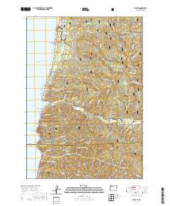
2020 Map of Yachats
USGS Topo · Published 2020About this map
Yachats and the coastal hamlet of San Marine serve as the primary human settlements on this stretch of the Oregon coast, where the mountains of the Siuslaw National Forest meet the Pacific. The landscape is defined by the steep drainage basins of the Yachats River and Cummins Creek, which cut through high points like Blodgett Peak and Kerby Mtn. Along the shoreline, geological and local landmarks such as Devils Churn, Cooks Chasm, and Agate Point illustrate the dynamic interface of land and sea. Genealogists and local historians can locate the Carson Cem in the eastern hills and Yachats Memorial Park near the town center. The presence of the Giant Spruce and the Big Cr Log Pond reflects the area's natural history and its connection to the timber industry, while the Oregon Coast Highway remains the vital artery connecting these isolated coastal communities.
Find a feature on this map
83 named features on this map. Tap any name to fly to it.
Don’t see what you’re looking for? This feature index may not catch every label — zoom into the map to look around manually.
Map Details
Editions of this 2020 Yachats Map
This is the sole edition of this map. No revisions or reprints were ever made.
Other maps of this area

1918 · Mapleton
USGS Topo · 1:48,000

1920 · Heceta Head
USGS Topo · 1:62,500

1922 · Waldport
USGS Topo · 1:62,500

1940 · Mapleton
USGS Topo · 1:62,500

1942 · Waldport
USGS Topo · 1:62,500

1942 · Heceta Head
USGS Topo · 1:62,500

1942 · Tidewater
USGS Topo · 1:62,500

1945 · Mapleton
USGS Topo · 1:62,500

1953 · Salem
USGS Topo · 1:250,000

1954 · Salem
USGS Topo · 1:250,000