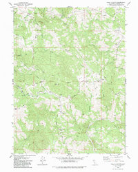
1979 Map of Yager Junction
USGS Topo · Published 1985About this map
Yager Junction sits at the heart of this landscape, marking the confluence of several branches of North Fork Yager Creek and South Fork Yager Creek. The terrain is defined by a series of working ranches and rural landmarks that suggest a quiet, land-dependent economy during the late 1970s. Key family and geographic nodes like Jaqua Ranch, Fort Baker Ranch, and Palace Rock Ranch appear alongside more localized points such as Sunny Basin Ranch.
Find a feature on this map
52 named features on this map. Tap any name to fly to it.
Don’t see what you’re looking for? This feature index may not catch every label — zoom into the map to look around manually.
Map Details
Editions of this 1979 Yager Junction Map
2 editions found
Other maps of this area

1914 · Pilot Creek
USGS Topo · 1:62,500

1915 · Big Bar and Vicinity
USGS Topo · 1:250,000

1921 · Dyerville
USGS Topo · 1:62,500

1922 · Kneeland
USGS Topo · 1:62,500

1949 · Blocksburg
USGS Topo · 1:62,500

1949 · Weott
USGS Topo · 1:62,500

1950 · Iaqua Buttes
USGS Topo · 1:62,500

1951 · Weott
USGS Topo · 1:62,500

1951 · Blocksburg
USGS Topo · 1:62,500

1951 · Pilot Creek
USGS Topo · 1:62,500