
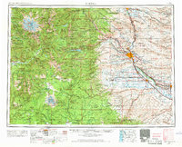
1958 Map of Yakima
USGS Topo · Published 1964About this map
MT Rainier and the jagged peaks of the Cascade Range dominate the western landscape of this mid-century survey, giving way to the fertile basins of the Yakima River. The irrigation infrastructure that transformed this region is clearly visible, including the Roza Canal and Sunnyside Canal, which allowed agriculture to flourish alongside the rail lines of the Northern Pacific and Union Pacific. The map provides a detailed view of the Yakima Indian Reservation, marking significant cultural and administrative sites like Fort Simcoe and the Yakima Indian Agency School.
Find a feature on this map
101 named features on this map. Tap any name to fly to it.
Don’t see what you’re looking for? This feature index may not catch every label — zoom into the map to look around manually.
Map Details
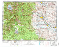
Editions of this 1958 Yakima Map
3 editions found
Other maps of this area

1897 · Mount Stuart
USGS Topo · 1:125,000

1897 · Tacoma
USGS Topo · 1:125,000

1899 · Ellensburg
USGS Topo · 1:125,000

1900 · Tacoma
USGS Topo · 1:125,000

1901 · Ellensburg
USGS Topo · 1:125,000

1901 · Snoqualmie Pass
USGS Topo · 1:125,000

1902 · Mount Aix
USGS Topo · 1:125,000

1902 · Mount Stuart
USGS Topo · 1:125,000

1903 · Snoqualmie
USGS Topo · 1:125,000

1904 · Mt Aix
USGS Topo · 1:125,000