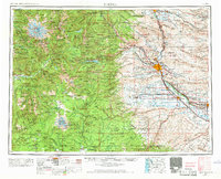
1958 Map of Yakima
USGS Topo · Published 1969About this map
Yakima and its surrounding valleys are defined by the convergence of the Naches River and Yakima River, serving as a hub for the irrigation-based agriculture of Central Washington in the late 1950s. The landscape transitions sharply from the volcanic peaks of Mount Rainier and Mount Adams in the west to the ridges of the Yakima Indian Reservation. A complex rail network including the Northern Pacific RR and the Chicago Milwaukee St Paul & Pacific RR illustrates the region's importance as a shipping corridor for the orchards of Selah, Gleed, and Wiley City. Extensive ridges such as Ahtanum Ridge and Toppenish Ridge frame the basin, while historical sites like Fort Simcoe Historical State Park and the Yakima Indian Agency School provide deep cultural context. The map also records essential infrastructure like the Yakima Airport and various pumping stations critical to the valley's water management system.
Find a feature on this map
115 named features on this map. Tap any name to fly to it.
Don’t see what you’re looking for? This feature index may not catch every label — zoom into the map to look around manually.
Map Details
Editions of this 1958 Yakima Map
3 editions found

Other maps of this area

1897 · Mount Stuart
USGS Topo · 1:125,000

1897 · Tacoma
USGS Topo · 1:125,000

1899 · Ellensburg
USGS Topo · 1:125,000

1900 · Tacoma
USGS Topo · 1:125,000

1901 · Ellensburg
USGS Topo · 1:125,000

1901 · Snoqualmie Pass
USGS Topo · 1:125,000

1902 · Mount Aix
USGS Topo · 1:125,000

1902 · Mount Stuart
USGS Topo · 1:125,000

1903 · Snoqualmie
USGS Topo · 1:125,000

1904 · Mt Aix
USGS Topo · 1:125,000