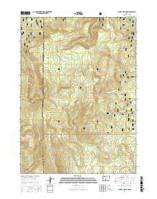
2017 Map of Yamsay Mountain
USGS Topo · Published 2017About this map
Yamsay Mtn dominates the western skyline of this high-elevation landscape on the border of Klamath and Lake Counties. This 2017 survey shows the convergence of the Winema National Forest and Fremont National Forest, a terrain defined by volcanic ridges and seasonal water sources. The map documents an intricate network of backcountry paths, including the Southern Oregon Intertie Trail and Antler Loop Trail, which provide access to remote features like Antler Springs and the expansive Calahan Meadow. Numerous drainages such as Calahan Cr and Deep Cr flow through the timbered slopes of Buck Ridge and Booth Ridge, illustrating the complex topography and drainage patterns characteristic of the eastern Cascades' transition into the high desert interior.
Find a feature on this map
47 named features on this map. Tap any name to fly to it.
Don’t see what you’re looking for? This feature index may not catch every label — zoom into the map to look around manually.
Map Details
Editions of this 2017 Yamsay Mountain Map
This is the sole edition of this map. No revisions or reprints were ever made.
Other maps of this area

1889 · Klamath
USGS Topo · 1:250,000

1894 · Klamath
USGS Topo · 1:250,000

1955 · Crescent
USGS Topo · 1:250,000

1955 · Klamath Falls
USGS Topo · 1:250,000

1957 · Crescent
USGS Topo · 1:250,000

1958 · Crescent
USGS Topo · 1:250,000

1958 · Klamath Falls
USGS Topo · 1:250,000

1960 · Sycan Marsh
USGS Topo · 1:62,500

1960 · Yamsay Mountain
USGS Topo · 1:62,500

1968 · Rodman Rock
USGS Topo · 1:24,000