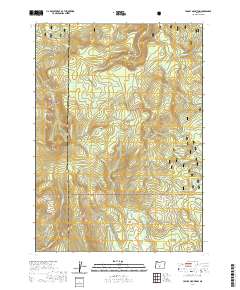
2020 Map of Yamsay Mountain
USGS Topo · Published 2020About this map
Yamsay Mtn dominates the high-elevation terrain where the Winema National Forest and Fremont National Forest meet at the boundary of Klamath and Lake Counties. This landscape is defined by its prominent volcanic topography, featuring significant landmarks like Buck Ridge, Jackson Ridge, and Booth Ridge. A network of high-country routes including the Southern Oregon Intertie Trail, Bluebuck Trail, and Antler Loop Trail provides access through this heavily forested region, which is drained by numerous small streams such as Knight Cr and W Fork Silver Cr. Scattered water sources like Antler Springs and Blue Buck Spring provide essential points of interest for those navigating the backcountry. In the southeastern portion of the quadrangle, the land opens into Calahan Meadow, offering a rare break in the timbered slopes that characterize this part of the Cascades.
Find a feature on this map
28 named features on this map. Tap any name to fly to it.
Don’t see what you’re looking for? This feature index may not catch every label — zoom into the map to look around manually.
Map Details
Editions of this 2020 Yamsay Mountain Map
This is the sole edition of this map. No revisions or reprints were ever made.
Other maps of this area

1889 · Klamath
USGS Topo · 1:250,000

1894 · Klamath
USGS Topo · 1:250,000

1955 · Crescent
USGS Topo · 1:250,000

1955 · Klamath Falls
USGS Topo · 1:250,000

1957 · Crescent
USGS Topo · 1:250,000

1958 · Crescent
USGS Topo · 1:250,000

1958 · Klamath Falls
USGS Topo · 1:250,000

1960 · Sycan Marsh
USGS Topo · 1:62,500

1960 · Yamsay Mountain
USGS Topo · 1:62,500

1968 · Rodman Rock
USGS Topo · 1:24,000