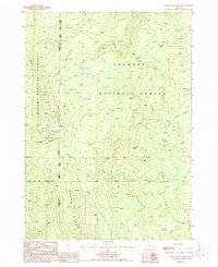
1988 Map of Yamsay Mountain
USGS Topo · Published 1988About this map
Yamsay Mountain dominates this portion of the high Cascades, where the borders of Winema National Forest and Fremont National Forest meet. The landscape is defined by the volcanic topography of Buck Ridge and Booth Ridge, intersected by a complex network of seasonal drainages including Bear Creek and Deep Creek. This 1980s-era survey preserves the alignment of the Old Indian Treaty Boundary, providing a specific historical marker of land tenure in Lake and Klamath counties. The map details a wild, hydrologically active area characterized by numerous water sources such as Blue Buck Spring and Antler Springs, which feed into meadows like Calahan Meadow. Evidence of resource extraction appears in the form of a Cinder Pit, while the rugged drainage systems of West Fork Silver Creek and Guyer Creek underscore the area's role as a vital watershed.
Find a feature on this map
21 named features on this map. Tap any name to fly to it.
Don’t see what you’re looking for? This feature index may not catch every label — zoom into the map to look around manually.
Map Details
Editions of this 1988 Yamsay Mountain Map
This is the sole edition of this map. No revisions or reprints were ever made.
Other maps of this area

1889 · Klamath
USGS Topo · 1:250,000

1894 · Klamath
USGS Topo · 1:250,000

1955 · Crescent
USGS Topo · 1:250,000

1955 · Klamath Falls
USGS Topo · 1:250,000

1957 · Crescent
USGS Topo · 1:250,000

1958 · Crescent
USGS Topo · 1:250,000

1958 · Klamath Falls
USGS Topo · 1:250,000

1960 · Sycan Marsh
USGS Topo · 1:62,500

1960 · Yamsay Mountain
USGS Topo · 1:62,500

1968 · Rodman Rock
USGS Topo · 1:24,000