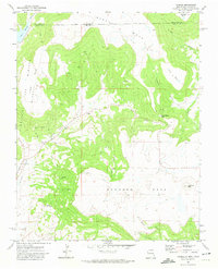
1971 Map of Yankee
USGS Topo · Published 1974About this map
Barela Mesa and Johnson Mesa dominate this high-altitude landscape along the Colorado and New Mexico border in the early 1970s. The settlement of Yankee sits at the junction of the Yankee East Fork Canyon and the East Fork, reflecting a history of resource extraction shown through numerous Mines and Prospects scattered across the surrounding slopes. An Old Railroad Grade winds along Chicorica Creek near Carisbrook, tracing a path past Maloya Lake toward the nearby ski basin. The terrain is defined by dramatic elevation changes at Manco Burro Pass and prominent summits like Towndrow Peak and Potato Mountain. This survey illustrates the transition from industrial mining activity to recreational land use, with several Jeep Trails cutting through the mesas once navigated by rail and heavy machinery.
Find a feature on this map
30 named features on this map. Tap any name to fly to it.
Don’t see what you’re looking for? This feature index may not catch every label — zoom into the map to look around manually.
Map Details
Editions of this 1971 Yankee Map
This is the sole edition of this map. No revisions or reprints were ever made.
Other maps of this area

1892 · Elmoro
USGS Topo · 1:125,000

1893 · Elmoro
USGS Topo · 1:125,000

1897 · Elmoro
USGS Topo · 1:125,000

1912 · Raton
USGS Topo · 1:62,500

1914 · Raton
USGS Topo · 1:62,500

1954 · Raton
USGS Topo · 1:250,000

1954 · Trinidad
USGS Topo · 1:250,000

1955 · Trinidad
USGS Topo · 1:250,000

1958 · Raton
USGS Topo · 1:250,000

1958 · Trinidad
USGS Topo · 1:250,000