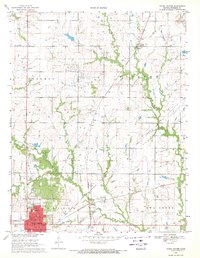
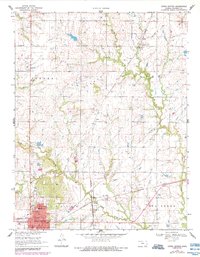
1969 Map of Yates Center
USGS Topo · Published 1971About this map
The county seat of Yates Center serves as the focal point of this late-1960s survey, showing a well-developed civic infrastructure including the Courthouse, City Hall, and a local Nursing Home. The surrounding Woodson County landscape is defined by the drainage of Owl Creek and Cherry Creek, which supported a dispersed network of smaller communities like Vernon, Hasty, and Durand. The influence of the petroleum industry is evident across the township, with numerous Oil Fields and individual Oil Well sites scattered throughout the terrain.
Find a feature on this map
32 named features on this map. Tap any name to fly to it.
Don’t see what you’re looking for? This feature index may not catch every label — zoom into the map to look around manually.
Map Details
Editions of this 1969 Yates Center Map
2 editions found
Other maps of this area

1885 · Burlington
USGS Topo · 1:125,000

1886 · Fredonia
USGS Topo · 1:125,000

1894 · Fredonia
USGS Topo · 1:125,000

1894 · Burlington
USGS Topo · 1:125,000

1947 · Lawrence
USGS Topo · 1:250,000

1947 · Joplin
USGS Topo · 1:250,000

1949 · Joplin
USGS Topo · 1:250,000

1950 · Lawrence
USGS Topo · 1:250,000

1954 · Joplin
USGS Topo · 1:250,000

1956 · Lawrence
USGS Topo · 1:250,000