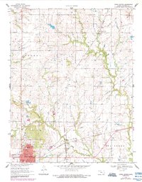
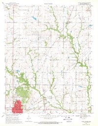
1969 Map of Yates Center
USGS Topo · Published 1984About this map
Yates Center serves as the focal point of this Woodson County study, where the town's street grid is clearly defined alongside landmarks like the Courthouse, City Hall, and a Radio Tower. The landscape reflects a Kansas prairie economy shaped by both agriculture and energy, with extensive Oil Fields and numerous Oil Wells peppered across the townships of Liberty, Vernon, and Everett. The Missouri Pacific railroad creates a diagonal axis through the terrain, connecting small settlements such as Durand and Vernon. Natural drainage is provided by Owl Creek and its tributaries, including North Owl Creek and Cherry Creek. Rural life is marked by scattered sites of local significance, from the Durand Sch and the Church of God to the Dutch Cem, which offer specific points of interest for genealogists tracing family roots in the region.
Find a feature on this map
27 named features on this map. Tap any name to fly to it.
Don’t see what you’re looking for? This feature index may not catch every label — zoom into the map to look around manually.
Map Details
Editions of this 1969 Yates Center Map
2 editions found
Other maps of this area

1885 · Burlington
USGS Topo · 1:125,000

1886 · Fredonia
USGS Topo · 1:125,000

1894 · Fredonia
USGS Topo · 1:125,000

1894 · Burlington
USGS Topo · 1:125,000

1947 · Lawrence
USGS Topo · 1:250,000

1947 · Joplin
USGS Topo · 1:250,000

1949 · Joplin
USGS Topo · 1:250,000

1950 · Lawrence
USGS Topo · 1:250,000

1954 · Joplin
USGS Topo · 1:250,000

1956 · Lawrence
USGS Topo · 1:250,000