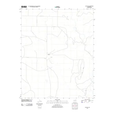
2010 Map of Yates SE
USGS Topo · Published 2010About this map
Dehaven and the variant spelling De Haven occupy the central high ground of this Harding County landscape, marking a sparse settlement pattern in the northeastern New Mexico cattle country. The terrain is defined by the sharp descent from a broad Mesa into the drainage of Ute Creek, which flows through the eastern portion of the quadrangle. This 2010 survey illustrates the persistence of the rural grid system, where long stretches of unpaved transit like County Road Z and County Road L-3 provide the primary infrastructure for isolated ranching outposts. Near the southern boundary, the name Gonzales appears alongside a cluster of structures, indicating small family or community pockets that remain vital in this arid environment. The map provides a clear look at the relationship between the elevated tablelands and the natural watercourses that dictate the placement of roads and homesteads.
Find a feature on this map
11 named features on this map. Tap any name to fly to it.
Don’t see what you’re looking for? This feature index may not catch every label — zoom into the map to look around manually.
Map Details
Editions of this 2010 Yates SE Map
This is the sole edition of this map. No revisions or reprints were ever made.
Other maps of this area

1954 · Tucumcari
USGS Topo · 1:250,000

1954 · Dalhart
USGS Topo · 1:250,000

1958 · Tucumcari
USGS Topo · 1:250,000

1958 · Dalhart
USGS Topo · 1:250,000

1962 · Dalhart
USGS Topo · 1:250,000

1973 · Yates SE
USGS Topo · 1:24,000

1973 · Beenham
USGS Topo · 1:24,000

1973 · Sabino
USGS Topo · 1:24,000
1973 · Bueyeros
USGS Topo · 1:24,000
1973 · Albert
USGS Topo · 1:24,000