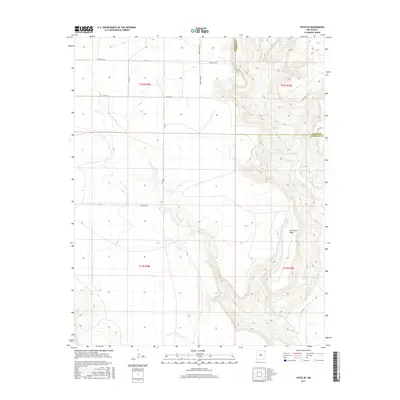
2017 Map of Yates SE
USGS Topo · Published 2017About this map
Ute Creek Mesa dominates the eastern half of this landscape on the border of Harding and Union counties. The terrain transitions from high, flat mesa land to the lower plains, shaped by the erosion of the Ute Creek drainage system. While the area is largely characterized by open range, the network of local roads reveals a history of family ranching and settlement. Dehaven Rd and Romero Bros Rd point to the local families who established themselves in this high-plains environment. Other named routes like Dorothy Rd, Lovato Rd, and Atkins Ln provide specific touchpoints for genealogists tracing ancestral landholdings in the ranchlands north of the Canadian River valley.
Find a feature on this map
19 named features on this map. Tap any name to fly to it.
Don’t see what you’re looking for? This feature index may not catch every label — zoom into the map to look around manually.
Map Details
Editions of this 2017 Yates SE Map
This is the sole edition of this map. No revisions or reprints were ever made.
Other maps of this area

1954 · Tucumcari
USGS Topo · 1:250,000

1954 · Dalhart
USGS Topo · 1:250,000

1958 · Tucumcari
USGS Topo · 1:250,000

1958 · Dalhart
USGS Topo · 1:250,000

1962 · Dalhart
USGS Topo · 1:250,000

1973 · Yates SE
USGS Topo · 1:24,000

1973 · Beenham
USGS Topo · 1:24,000

1973 · Sabino
USGS Topo · 1:24,000
1973 · Bueyeros
USGS Topo · 1:24,000
1973 · Albert
USGS Topo · 1:24,000