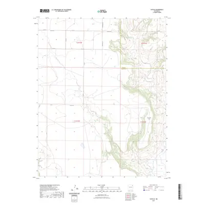
2023 Map of Yates SE
USGS Topo · Published 2023About this map
Ute Creek Mesa dominates the eastern edge of this high plains landscape, where steep escarpments drop away from the level plateau. The region is defined by a sparse network of county roads that follow the township and range lines of the Public Land Survey System, including Romero Bros Rd and Lovato Rd. These family-named routes suggest the long-standing ranching heritage of the Union and Harding County line. The terrain transitions from the flat tablelands near Clavel Rd to the intricate drainage patterns carved into the mesa's edge. This modern survey illustrates the enduring rural structure of northeastern New Mexico, where large-scale land divisions and remote homestead access points like Dorothy Rd and Dehaven Rd remain the primary indicators of human presence and navigation across the dry, open country.
Find a feature on this map
18 named features on this map. Tap any name to fly to it.
Don’t see what you’re looking for? This feature index may not catch every label — zoom into the map to look around manually.
Map Details
Editions of this 2023 Yates SE Map
This is the sole edition of this map. No revisions or reprints were ever made.
Other maps of this area

1954 · Tucumcari
USGS Topo · 1:250,000

1954 · Dalhart
USGS Topo · 1:250,000

1958 · Tucumcari
USGS Topo · 1:250,000

1958 · Dalhart
USGS Topo · 1:250,000

1962 · Dalhart
USGS Topo · 1:250,000

1973 · Yates SE
USGS Topo · 1:24,000

1973 · Beenham
USGS Topo · 1:24,000

1973 · Sabino
USGS Topo · 1:24,000
1973 · Bueyeros
USGS Topo · 1:24,000
1973 · Albert
USGS Topo · 1:24,000