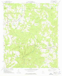
1973 Map of Yatesville
USGS Topo · Published 1976About this map
Yatesville serves as the focal point of this 1970s landscape, situated at the intersection of the Southern and Central of Georgia rail lines. The convergence of these railroads at Topeka Junction underscores the area's historical reliance on rail transport for agricultural and regional connectivity. The map captures a transition period where traditional rural infrastructure, evidenced by numerous country churches such as Liberty Chapel and Andrews Chapel, remains prominent against the wooded drainage basins of Tobler Creek and Auchumpkee Creek.
Find a feature on this map
30 named features on this map. Tap any name to fly to it.
Don’t see what you’re looking for? This feature index may not catch every label — zoom into the map to look around manually.
Map Details
Editions of this 1973 Yatesville Map
This is the sole edition of this map. No revisions or reprints were ever made.
Other maps of this area

1935 · Thomaston
USGS Topo · 1:48,000

1939 · Thomaston
USGS Topo · 1:62,500

1951 · Yatesville
USGS Topo · 1:62,500

1951 · Barnesville
USGS Topo · 1:62,500

1953 · Atlanta
USGS Topo · 1:250,000

1955 · Phenix City
USGS Topo · 1:250,000

1957 · Phenix City
USGS Topo · 1:250,000

1957 · Atlanta
USGS Topo · 1:250,000

1958 · Phenix City
USGS Topo · 1:250,000

1958 · Atlanta
USGS Topo · 1:250,000