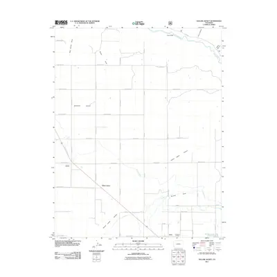
2011 Map of Yellow Jacket
USGS Topo · Published 2011About this map
Yellow Jacket serves as a central point in this agricultural landscape of southwestern Colorado, where the high desert plateau is intricately carved by canyons and managed through a network of irrigation works. The engineering of the high plains is evident in the Dove Creek Canal and the U Lateral, which divert water across the mesa to support local farming. To the northeast, the Dolores River winds through its deep valley near the settlement of Lone Dome, while the southern reaches of the quadrangle feature the Narraguinnep Reservoir and the community of Lewis. Local heritage is anchored by sites like Fairview Cemetery and Sunnyside Cemetery, which sit among a landscape defined by dramatic topographical shifts into Yellow Jacket Canyon and Sandstone Canyon. The map reveals a grid of county roads that navigate the complex transition between flat farmlands and the rugged draws of Ryman Draw and Brumley Draw.
Find a feature on this map
36 named features on this map. Tap any name to fly to it.
Don’t see what you’re looking for? This feature index may not catch every label — zoom into the map to look around manually.
Map Details
Editions of this 2011 Yellow Jacket Map
This is the sole edition of this map. No revisions or reprints were ever made.
Other maps of this area

1956 · Cortez
USGS Topo · 1:250,000

1958 · Cortez
USGS Topo · 1:250,000

1959 · Cortez
USGS Topo · 1:250,000

1962 · Cortez
USGS Topo · 1:250,000

1965 · Cahone
USGS Topo · 1:24,000

1965 · Woods Canyon
USGS Topo · 1:24,000

1965 · Dolores West
USGS Topo · 1:24,000

1965 · Yellow Jacket
USGS Topo · 1:24,000
1965 · Arriola
USGS Topo · 1:24,000
1965 · Pleasant View
USGS Topo · 1:24,000