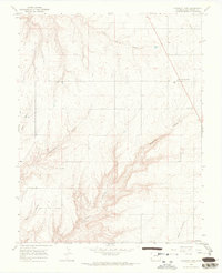
1965 Map of Pleasant View
USGS Topo · Published 1968About this map
Pleasant View sits at a high point in the Four Corners region, overlooking a complex drainage system that feeds into the nearby desert landscapes. This 1964 photogrammetric survey reveals a land defined by its deep incisions, where the high plateau is sliced by the sheer walls of Sandstone Canyon and Hovenweep Canyon. The settlement pattern follows the relatively level ground between these geological features, with agriculture and roads concentrated on the mesas above the canyon floors. Significant watercourses like Little Cahone Canyon and Woods Canyon create a finger-like pattern of ridges and draws across the quadrangle. In the lower reaches of the map, the terrain becomes increasingly complex as Ruin Canyon and Negro Canyon converge, illustrating the difficult geography that guided early settlement and transit routes in Montezuma County.
Find a feature on this map
19 named features on this map. Tap any name to fly to it.
Don’t see what you’re looking for? This feature index may not catch every label — zoom into the map to look around manually.
Map Details
Editions of this 1965 Pleasant View Map
2 editions found
Other maps of this area

1956 · Cortez
USGS Topo · 1:250,000

1957 · Moqui NW
USGS Topo · 1:24,000

1957 · Cedar 3 NW
USGS Topo · 1:24,000

1957 · Cedar 3 SW
USGS Topo · 1:24,000

1958 · Cortez
USGS Topo · 1:250,000

1959 · Cortez
USGS Topo · 1:250,000

1962 · Cortez
USGS Topo · 1:250,000

1965 · Cahone
USGS Topo · 1:24,000

1965 · Woods Canyon
USGS Topo · 1:24,000

1965 · Yellow Jacket
USGS Topo · 1:24,000