
1957 Map of Cedar 3 NW
USGS Topo · Published 1958About this map
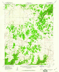
Point Lookout dominates the central landscape of this mid-century survey, marking the high ground between the deeply incised drainages of the Colorado plateau. The map captures a transitional era of water management in this arid region, evidenced by numerous reservoirs and Lower Monument Reservoir situated along Monument Creek. A notable site for local historians is the School (Aban'd) located near the head of Squaw Canyon, reflecting the consolidation or movement of rural communities as the mid-1950s approached. The terrain is defined by dramatic elevation changes where the plateau drops off into Cross Canyon and Alkali Canyon, while Champagne Spring provides a rare perennial water source in the canyon lands. The boundary between Dolores and Montezuma Counties bisects the southern portion of the sheet, cutting across the rugged canyon floors.
Find a feature on this map
12 named features on this map. Tap any name to fly to it.
Don’t see what you’re looking for? This feature index may not catch every label — zoom into the map to look around manually.
Map Details
Editions of this 1957 Cedar 3 NW Map
This is the sole edition of this map. No revisions or reprints were ever made.
Other maps of this area

1886 · Abajo
USGS Topo · 1:250,000

1892 · Abajo
USGS Topo · 1:250,000

1893 · Abajo
USGS Topo · 1:250,000

1956 · Cortez
USGS Topo · 1:250,000

1957 · Cedar 3 SW
USGS Topo · 1:24,000

1957 · Monument Canyon
USGS Topo · 1:62,500
1957 · Eastland
USGS Topo · 1:62,500
1958 · Verdure 4 NE
USGS Topo · 1:24,000

1958 · Cortez
USGS Topo · 1:250,000
1958 · Verdure 4 SE
USGS Topo · 1:24,000