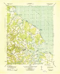
1943 Map of Yeocomico
USGS Topo · Published 1943About this map
The settlement of Kinsale serves as a focal point on this 1943 survey, situated where the Yeocomico River meets the intricate finger-like branches of the Northern Neck. The landscape is defined by its deep maritime connection, characterized by numerous points and coves like Sloop Pt, White Pt, and Palmer Cove. Small agricultural and community hubs such as Tucker Hill and Westmoreland are connected by a network of roads that bridge the low-lying terrain at crossings like the Hampton Hall Bridge.
Find a feature on this map
60 named features on this map. Tap any name to fly to it.
Don’t see what you’re looking for? This feature index may not catch every label — zoom into the map to look around manually.
Map Details
Editions of this 1943 Yeocomico Map
2 editions found
Other maps of this area

1892 · Piney Point
USGS Topo · 1:62,500

1894 · Piney Point
USGS Topo · 1:62,500

1894 · Point Lookout
USGS Topo · 1:62,500

1895 · Nomini
USGS Topo · 1:125,000

1895 · Piney Point
USGS Topo · 1:62,500

1898 · Nomini
USGS Topo · 1:125,000

1898 · St. Marys
USGS Topo · 1:125,000

1901 · Piney Point
USGS Topo · 1:62,500

1906 · St. Marys
USGS Topo · 1:125,000

1912 · Point Lookout
USGS Topo · 1:62,500