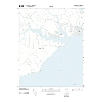
2010 Map of Yeopim River
USGS Topo · Published 2010About this map
The Yeopim River cuts through this coastal landscape, serving as a defining geographical feature where it meets the broad expanse of the Albemarle Sound. Small residential clusters and historic settlements characterize the area, with Bethel situated inland and waterfront communities like Snug Harbor and Holiday Island lining the river's northern banks. The presence of Philips Cemetery and Philips Landing provides valuable markers for genealogical research and local history, while the southern reaches of the quadrangle are anchored by the Laurel Point Light House in the open waters. The terrain is shaped by numerous tributaries such as Bethel Creek, Yeopim Creek, and Burnt Mill Creek, illustrating the intricate drainage patterns that influenced local land use and development. Prominent landmarks like Drummond Point and Bluff Point define the jagged shoreline, marking the transition from riverine environments to the sound.
Find a feature on this map
46 named features on this map. Tap any name to fly to it.
Don’t see what you’re looking for? This feature index may not catch every label — zoom into the map to look around manually.
Map Details
Editions of this 2010 Yeopim River Map
This is the sole edition of this map. No revisions or reprints were ever made.
Other maps of this area

1904 · Edenton
USGS Topo · 1:62,500

1906 · Hertford
USGS Topo · 1:62,500

1940 · Hertford
USGS Topo · 1:62,500

1942 · Edenton
USGS Topo · 1:62,500

1943 · Columbia
USGS Topo · 1:125,000

1943 · Plymouth
USGS Topo · 1:125,000

1943 · Edenton
USGS Topo · 1:62,500

1953 · Norfolk
USGS Topo · 1:250,000

1953 · Columbia West
USGS Topo · 1:24,000

1953 · Rocky Mount
USGS Topo · 1:250,000