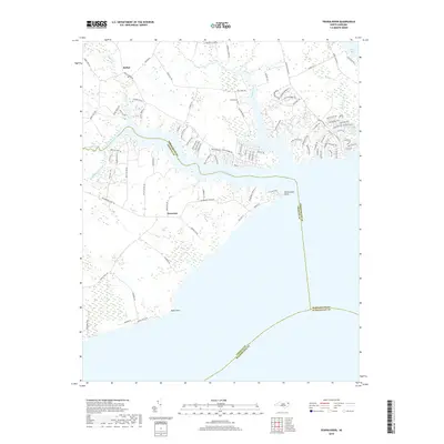
2019 Map of Yeopim River
USGS Topo · Published 2019About this map
The Yeopim River dominates this coastal landscape where Chowan Co, Perquimans Co, and Washington Co converge in the Albemarle Sound region. The settlement of Somerset sits at a crossroads near the river's south bank, while Bethel occupies the northern reaches where Bethel Creek flows into the main waterway. This map captures the intricate shoreline of the Inner Banks, defined by prominent landforms such as Drummond Point and Bluff Point. The interior landscape reveals a network of residential development, particularly around Yeopim Creek, evidenced by names like Dogwood Dr and Casters Cove Way. Genealogists may find value in the location of Philips Cem near the northern shore. The extensive wetlands bordering Middleton Creek and Burnt Mill Creek illustrate the low-lying, hydrologically complex nature of this North Carolina coastal plain environment.
Find a feature on this map
101 named features on this map. Tap any name to fly to it.
Don’t see what you’re looking for? This feature index may not catch every label — zoom into the map to look around manually.
Map Details
Editions of this 2019 Yeopim River Map
This is the sole edition of this map. No revisions or reprints were ever made.
Other maps of this area

1904 · Edenton
USGS Topo · 1:62,500

1906 · Hertford
USGS Topo · 1:62,500

1940 · Hertford
USGS Topo · 1:62,500

1942 · Edenton
USGS Topo · 1:62,500

1943 · Columbia
USGS Topo · 1:125,000

1943 · Plymouth
USGS Topo · 1:125,000

1943 · Edenton
USGS Topo · 1:62,500

1953 · Norfolk
USGS Topo · 1:250,000

1953 · Columbia West
USGS Topo · 1:24,000

1953 · Rocky Mount
USGS Topo · 1:250,000