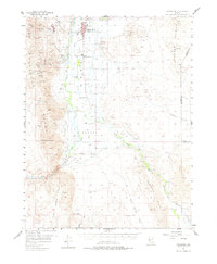
1957 Map of Yerington
USGS Topo · Published 1976About this map
The agricultural and mining heart of the Mason Valley is documented in this 1957 survey, where the Walker River splits into the West Walker and East Walker forks. The city of Yerington serves as the regional hub, flanked by the sprawling industrial footprint of the Yerington Mine and the company town of Weed Heights. This era shows a landscape heavily engineered for water, featuring an intricate network of irrigation channels like the Mickey Ditch, Alkali Ditch, and S Side Canal that transformed the arid Missouri Flat into productive acreage.
Find a feature on this map
67 named features on this map. Tap any name to fly to it.
Don’t see what you’re looking for? This feature index may not catch every label — zoom into the map to look around manually.
Map Details
Editions of this 1957 Yerington Map
3 editions found

Other maps of this area

1891 · Wabuska
USGS Topo · 1:125,000

1891 · Wellington
USGS Topo · 1:125,000

1893 · Wellington
USGS Topo · 1:125,000

1894 · Wabuska
USGS Topo · 1:125,000

1908 · Carson Sink
USGS Topo · 1:250,000

1909 · Hawthorne
USGS Topo · 1:250,000

1910 · Carson Sink
USGS Topo · 1:250,000

1911 · Hawthorne
USGS Topo · 1:250,000

1915 · Hawthorne
USGS Topo · 1:250,000

1948 · Walker Lake
USGS Topo · 1:250,000