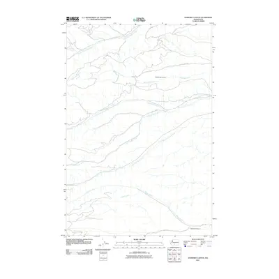
2011 Map of Yesmowit Canyon
USGS Topo · Published 2011About this map
Yesmowit Canyon and the surrounding drainage basins of the Yakima region appear here as a network of deeply etched creek beds and Bureau of Indian Affairs roads. The geography is defined by parallel watercourses flowing eastward, including South Fork Ahtanum Creek and Rattlesnake Creek, which cut through the high terrain to form Rattlesnake Canyon. A notable point of interest is Soda Springs, located along the banks of North Fork Simcoe Creek. The map provides a look at the rural infrastructure of the early 21st century, with various access routes like County HWY 5 and Bia 147 RD navigating the divides between Diamond Dick Creek and Wahtum Creek. This layout suggests a landscape managed for resource access and tribal transit, where the naming of even small tributaries like Spencer Creek reflects the specific local importance of water in this arid stretch of Washington.
Find a feature on this map
16 named features on this map. Tap any name to fly to it.
Don’t see what you’re looking for? This feature index may not catch every label — zoom into the map to look around manually.
Map Details
Editions of this 2011 Yesmowit Canyon Map
This is the sole edition of this map. No revisions or reprints were ever made.
Other maps of this area

1899 · Ellensburg
USGS Topo · 1:125,000

1901 · Ellensburg
USGS Topo · 1:125,000

1902 · Mount Aix
USGS Topo · 1:125,000

1904 · Mt Aix
USGS Topo · 1:125,000

1904 · Mount Adams
USGS Topo · 1:125,000

1907 · Mount Adams
USGS Topo · 1:125,000

1937 · White Swan
USGS Topo · 1:125,000

1950 · Yakima
USGS Topo · 1:250,000

1957 · Yesmowit Canyon
USGS Topo · 1:24,000
1957 · Willy Dick Canyon
USGS Topo · 1:24,000