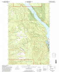
1994 Map of Yew Creek
USGS Topo · Published 1996About this map
The eastern slopes of the Mission Range dominate this landscape, which drops toward the clear waters of Swan Lake in the Lake County backcountry. At the southern end of the lake, the Swan River National Wildlife Refuge marks a critical riparian habitat where the Swan River enters the basin. This mid-1990s survey illustrates a complex intersection of land management, showing where the Flathead National Forest meets the northern boundary of the Flathead Indian Reservation. Numerous drainages like Crane Creek, Bug Creek, and Lolo Creek carve through the heavily timbered terrain, revealing a network of forestry roads and the occasional Gravel Pit. Near the reservation boundary, the presence of Mission Well indicates essential water infrastructure in this steep, high-elevation environment.
Find a feature on this map
34 named features on this map. Tap any name to fly to it.
Don’t see what you’re looking for? This feature index may not catch every label — zoom into the map to look around manually.
Map Details
Editions of this 1994 Yew Creek Map
This is the sole edition of this map. No revisions or reprints were ever made.
Other maps of this area

1914 · Nyack
USGS Topo · 1:125,000

1920 · Flathead Lake
USGS Topo · 1:125,000

1943 · Kalispell
USGS Topo · 1:125,000

1955 · Choteau
USGS Topo · 1:250,000

1956 · Wallace
USGS Topo · 1:250,000

1957 · Choteau
USGS Topo · 1:250,000

1957 · Kalispell
USGS Topo · 1:250,000

1958 · Choteau
USGS Topo · 1:250,000

1960 · Kalispell
USGS Topo · 1:250,000

1960 · Wallace
USGS Topo · 1:250,000