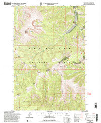
1995 Map of Yogo Peak
USGS Topo · Published 1997About this map
Dry Wolf and the high ridges of the Little Belt Mountains define this landscape within the Lewis and Clark National Forest. The area is characterized by a dense network of gulches and peaks, where drainage patterns from Dry Wolf Creek and Yogo Creek carve through the terrain. Evidence of the region’s mineral interest is found at the Dry Wolf site, while the high elevations are marked by landmarks like Big Baldy Mountain, Cabin Mountain, and the namesake Yogo Peak. These mountains hide several alpine water bodies, including Twin Lakes, Rhoda Lake, and Lake Elva. Managed under the Judith Kings Hill Ranger District, the map details a wilderness environment of steep relief, including Prospect Ridge and Slide Rock Point, where natural features were the primary focus of 1990s forest management and geological study.
Find a feature on this map
29 named features on this map. Tap any name to fly to it.
Don’t see what you’re looking for? This feature index may not catch every label — zoom into the map to look around manually.
Map Details
Editions of this 1995 Yogo Peak Map
2 editions found
Other maps of this area

1886 · Little Belt Mts.
USGS Topo · 1:250,000

1890 · Fort Benton
USGS Topo · 1:250,000

1892 · Fort Benton
USGS Topo · 1:250,000

1894 · Little Belt Mts.
USGS Topo · 1:250,000

1897 · Fort Benton
USGS Topo · 1:250,000

1897 · Little Belt Mts.
USGS Topo · 1:250,000

1898 · Little Belt Mts.
USGS Topo · 1:250,000

1902 · Little Belt Mts.
USGS Topo · 1:250,000

1948 · White Sulphur Springs
USGS Topo · 1:250,000

1954 · Great Falls
USGS Topo · 1:250,000