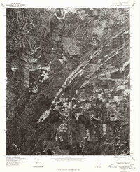
1975 Map of Yolande SW
USGS Topo · Published 1977About this map
Abernant and Yolande anchor this mid-1970s orthophotoquad, which uses aerial imagery to reveal the complex industrial and residential patterns in this corner of Tuscaloosa County. The visual data, rectified from 1975 photography, shows a landscape defined by significant surface modifications and cleared corridors, reflecting the region's long history with resource extraction and mining. Unlike a traditional line-drawn map, this imagery-based study exposes the exact footprint of small settlements like Aubrey alongside the winding haul roads and cleared tracts that bypass the wooded ridges. The Soil Conservation Service and Geological Survey collaborated on this production, providing researchers with a clear view of land-use shifts and rural infrastructure before the sprawl of later decades changed the character of these Alabama communities.
Find a feature on this map
3 named features on this map. Tap any name to fly to it.
Don’t see what you’re looking for? This feature index may not catch every label — zoom into the map to look around manually.
Map Details
Editions of this 1975 Yolande SW Map
This is the sole edition of this map. No revisions or reprints were ever made.
Other maps of this area

1899 · Brookwood
USGS Topo · 1:125,000

1927 · Adger
USGS Topo · 1:48,000

1929 · Searles
USGS Topo · 1:48,000

1931 · Cottondale
USGS Topo · 1:48,000

1932 · Yolande
USGS Topo · 1:62,500

1934 · Searles
USGS Topo · 1:62,500

1934 · Cottondale
USGS Topo · 1:62,500

1934 · Blocton
USGS Topo · 1:48,000

1935 · Yolande
USGS Topo · 1:62,500

1940 · Blocton
USGS Topo · 1:62,500