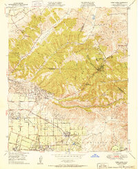
1950 Map of Yorba Linda
USGS Topo · Published 1950About this map
The Olinda Oil Field dominates the western hills of this 1950 survey, marking a period where petroleum extraction and citrus ranching defined the landscape of northern Orange County. The transition from industrial hill country to the developing residential and agricultural grids is evident in the layout of Yorba Linda and Placentia, where streets like Valencia Ave and Alta Vista Ave begin to organize the terrain. In the canyons of the Santa Ana Mountains, natural features such as La Vida Mineral Springs and Carbon Canyon Mineral Springs highlight the era's local recreation and wellness destinations.
Find a feature on this map
47 named features on this map. Tap any name to fly to it.
Don’t see what you’re looking for? This feature index may not catch every label — zoom into the map to look around manually.
Map Details
Editions of this 1950 Yorba Linda Map
This is the sole edition of this map. No revisions or reprints were ever made.
Other maps of this area

1894 · Pomona
USGS Topo · 1:62,500

1896 · Anaheim
USGS Topo · 1:62,500

1897 · Pomona
USGS Topo · 1:62,500

1897 · Cucamonga
USGS Topo · 1:62,500

1898 · Pomona
USGS Topo · 1:62,500

1898 · Anaheim
USGS Topo · 1:62,500

1900 · Cucamonga
USGS Topo · 1:62,500

1901 · Southern California Sheet No. 1
USGS Topo · 1:250,000

1901 · Anaheim
USGS Topo · 1:62,500

1902 · Corona
USGS Topo · 1:125,000