1956 Map of York Beach
USGS Topo · Published 1963About this map
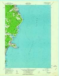
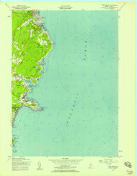
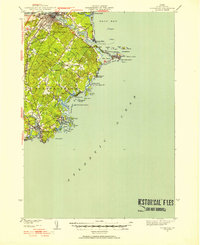
Cape Neddick Lighthouse stands as a primary navigational sentinel on this mid-century topographic record of the Maine coastline. The transition from the rocky headlands of Israels Head and Bald Head to the developed seasonal settlements reflects the area's mid-century identity. In Ogunquit, the map details a dense cluster of coastal development near Ogunquit Beach, while further south, the Railroad Grade traces a former transportation corridor that once linked these shore communities. The interior is marked by several freshwater bodies such as Staples Pond and Lake Carolyn, providing a contrast to the salt spray of Cape Neddick Harbor. Significant local infrastructure, including the Blue Star Memorial Highway, indicates the post-war growth in regional accessibility that shaped towns like York Beach and Concordville.
Find a feature on this map
60 named features on this map. Tap any name to fly to it.
Don’t see what you’re looking for? This feature index may not catch every label — zoom into the map to look around manually.
Map Details
Editions of this 1956 York Beach Map
3 editions found

Other maps of this area

1891 · Biddeford
USGS Topo · 1:62,500

1891 · Kennebunk
USGS Topo · 1:62,500

1893 · Kennebunk
USGS Topo · 1:62,500

1893 · York
USGS Topo · 1:62,500

1893 · Biddeford
USGS Topo · 1:62,500

1898 · Kennebunk
USGS Topo · 1:62,500

1920 · York
USGS Topo · 1:62,500
1941 · Biddeford
USGS Topo · 1:62,500

1941 · Kennebunk
USGS Topo · 1:62,500

1944 · Wells
USGS Topo · 1:24,000