1977 Map of York Harbor
USGS Topo · Published 1979About this map
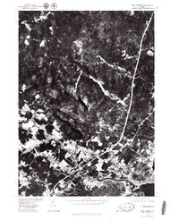
The winding course of the York River dominates this 1977 aerial perspective, showing the transition from the tidal marshes and coastal density of York Harbor to the wooded interior of York County. The orthophoto format provides a clear view of the late-1970s landscape, where small inland settlements like Scotland and Beech Ridge maintain a rural character amidst dense forest cover. Further north, the confluence of roads at Brixham Lower Corners stands out against the dark timberland, while the Great Works River cuts through the northwest corner of the sheet. This survey, produced by the Geological Survey in cooperation with the Soil Conservation Service, captures the exact state of Maine's southern coastline just before the significant residential expansion of the following decades, documenting the early interstate highway corridors and traditional harbor layouts where the river meets the Atlantic Ocean.
Find a feature on this map
7 named features on this map. Tap any name to fly to it.
Don’t see what you’re looking for? This feature index may not catch every label — zoom into the map to look around manually.
Map Details
Editions of this 1977 York Harbor Map
This is the sole edition of this map. No revisions or reprints were ever made.
Other maps of this area

1891 · Berwick
USGS Topo · 1:62,500

1891 · Kennebunk
USGS Topo · 1:62,500

1893 · Kennebunk
USGS Topo · 1:62,500

1893 · Dover
USGS Topo · 1:62,500

1893 · Berwick
USGS Topo · 1:62,500

1893 · York
USGS Topo · 1:62,500

1898 · Kennebunk
USGS Topo · 1:62,500

1916 · Dover
USGS Topo · 1:62,500

1918 · Dover
USGS Topo · 1:62,500

1920 · York
USGS Topo · 1:62,500