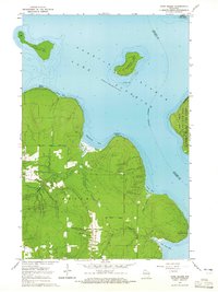
1964 Map of York Island
USGS Topo · Published 1965About this map
The waters of Lake Superior surround the northernmost reaches of Wisconsin's mainland and the southwestern chain of the Apostle Islands. Much of the mainland peninsula is occupied by the Red Cliff Indian Reservation, where the landscape is defined by the winding paths of the Raspberry River and Red Cliff Creek. At this time in the mid-1960s, the shoreline remains mostly undeveloped, punctuated by navigational landmarks such as the Light on Raspberry Island and the prominent Point Detour.
Find a feature on this map
27 named features on this map. Tap any name to fly to it.
Don’t see what you’re looking for? This feature index may not catch every label — zoom into the map to look around manually.
Map Details
Editions of this 1964 York Island Map
This is the sole edition of this map. No revisions or reprints were ever made.
Other maps of this area

1941 · Bayfield
USGS Topo · 1:48,000

1946 · Bayfield
USGS Topo · 1:48,000

1953 · Ashland
USGS Topo · 1:250,000

1954 · Two Harbors
USGS Topo · 1:250,000

1957 · Two Harbors
USGS Topo · 1:250,000

1958 · Ashland
USGS Topo · 1:250,000

1958 · Two Harbors
USGS Topo · 1:250,000

1963 · Rocky Island
USGS Topo · 1:62,500

1963 · Oak Island
USGS Topo · 1:24,000
1963 · Bear Island
USGS Topo · 1:24,000