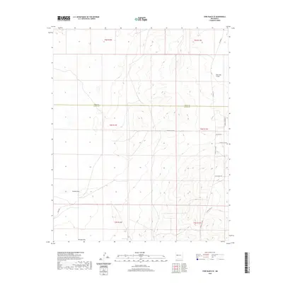
2020 Map of York Ranch SE
USGS Topo · Published 2020About this map
The Cibola Co Catron Co line divides this stretch of high-desert terrain, where isolated water sources and long-distance trails define the land's utility. Elsies Tank and Veteado Draw provide the primary hydrographic landmarks in a landscape otherwise shaped by drainage systems like Goat Tank Canyon. The area is characterized by its network of modern ranch and local roads, many bearing names that evoke the regional history of the American West. Key routes include the north-south Pie Town Rd and the evocatively named Pony Express Trl, which suggests the historical movement of post and people through this part of New Mexico. The map illustrates the structured Public Land Survey System grid across multiple townships, including t4n r12w and t4n r11w, overlaying a topography of subtle elevation changes and dry washes.
Find a feature on this map
19 named features on this map. Tap any name to fly to it.
Don’t see what you’re looking for? This feature index may not catch every label — zoom into the map to look around manually.
Map Details
Editions of this 2020 York Ranch SE Map
This is the sole edition of this map. No revisions or reprints were ever made.
Other maps of this area

1917 · Broom Mountain
USGS Topo · 1:125,000

1954 · Saint Johns
USGS Topo · 1:250,000

1954 · Socorro
USGS Topo · 1:250,000

1957 · Saint Johns
USGS Topo · 1:250,000

1958 · Socorro
USGS Topo · 1:250,000

1958 · Saint Johns
USGS Topo · 1:250,000

1962 · Socorro
USGS Topo · 1:250,000

1962 · Saint Johns
USGS Topo · 1:250,000
1964 · Sand Canyon
USGS Topo · 1:24,000

1964 · Third Canyon
USGS Topo · 1:24,000