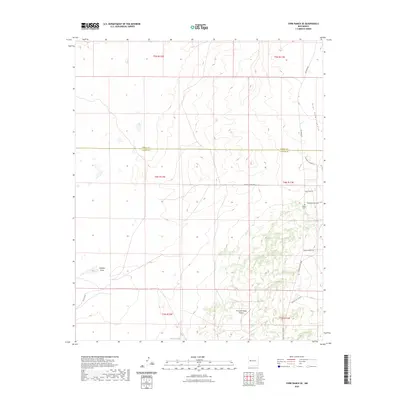
2023 Map of York Ranch SE
USGS Topo · Published 2023About this map
Porcupine Ridge Airport sits on a high plateau in northern Catron County, serving as a remote aviation landmark in this sparsely populated region. The landscape is defined by drainage patterns like Veteado Draw and Goat Tank Canyon, which cut through the high-desert terrain. Local history is anchored at the Greer Cem, located along the eastern edge of the survey area near the Cibola and Catron County line. The modern road network, including the evocative Pony Express Trl and Trail Boss Rd, traces the routes of earlier livestock movements and historical trails. Resource management in this arid environment is evident by the presence of Elsies Tank, a vital water catchment for ranching operations across the Porcupine Ridge vicinity.
Find a feature on this map
22 named features on this map. Tap any name to fly to it.
Don’t see what you’re looking for? This feature index may not catch every label — zoom into the map to look around manually.
Map Details
Editions of this 2023 York Ranch SE Map
This is the sole edition of this map. No revisions or reprints were ever made.
Other maps of this area

1917 · Broom Mountain
USGS Topo · 1:125,000

1954 · Saint Johns
USGS Topo · 1:250,000

1954 · Socorro
USGS Topo · 1:250,000

1957 · Saint Johns
USGS Topo · 1:250,000

1958 · Socorro
USGS Topo · 1:250,000

1958 · Saint Johns
USGS Topo · 1:250,000

1962 · Socorro
USGS Topo · 1:250,000

1962 · Saint Johns
USGS Topo · 1:250,000
1964 · Sand Canyon
USGS Topo · 1:24,000

1964 · Third Canyon
USGS Topo · 1:24,000