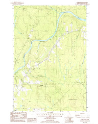
1986 Map of York Ridge
USGS Topo · Published 1986About this map
The Aroostook River winds through the heart of this North Woods landscape, defining the topography of central Aroostook County in the mid-1980s. The terrain is marked by the prominent York Ridge and the heights of Castle Hill, where a local Cem and several Gravel Pits indicate the small-scale infrastructure of rural Maine. Settled areas like Frenchville are connected by a network of unimproved roads and a significant Trans Line corridor that cuts through the forested townships. Numerous small water bodies and streams, including Schoolhouse Brook, Gardner Brook, and Squa Pan Inlet, drain the timberlands. The survey reveals a landscape of working forests and scattered townships like Ashland and Wade, where the river remains the primary geographic anchor for these communities.
Find a feature on this map
24 named features on this map. Tap any name to fly to it.
Don’t see what you’re looking for? This feature index may not catch every label — zoom into the map to look around manually.
Map Details
Editions of this 1986 York Ridge Map
This is the sole edition of this map. No revisions or reprints were ever made.
Other maps of this area

1929 · Portage
USGS Topo · 1:62,500

1929 · Caribou
USGS Topo · 1:48,000

1931 · Ashland
USGS Topo · 1:48,000

1931 · Portage
USGS Topo · 1:62,500

1932 · Caribou
USGS Topo · 1:62,500

1934 · Ashland
USGS Topo · 1:62,500

1935 · Presque Isle
USGS Topo · 1:62,500

1953 · Ashland
USGS Topo · 1:62,500

1953 · Portage
USGS Topo · 1:62,500

1953 · Presque Isle
USGS Topo · 1:62,500